Hartlepool Sports & Leisure
Hartlepool Transport
A Potted History Of Hartlepool
Hartlepool Trade & Industry
Hartlepool Health & Education
Hartlepool People
Hartlepool Places
Hartlepool at War
Hartlepool Ships & Shipping

A.D. 1485
What we know about this image :
1485 AD
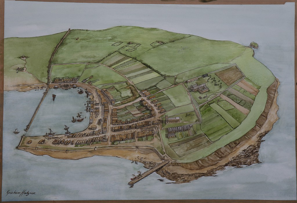
In 2004, Tees Archaeology, Hartlepool Borough Council and The Headland History Group supported by the Heritage Lottery Fund produced a set of four posters which reconstructed the town of Hartlepool over 1300 years.
Graham Hodgson, an archaeological illustrator painted four watercolours of the town for this project. The images are of the original artwork and the notes give the information which was on the posters.
Here is the town of Hartlepool in the year 1485 AD, the first year of the Tudor king Henry V11. The town had prospered since the Norman period some 350 years earlier when the De Brus family had developed Hartlepool as a port for the city of Durham. They laid out the street plan familiar to us today and ordered the building of the first docks and quayside. The town’s status was raised when local merchants bought a Charter from King John in 1201 allowing them to hold a regular market and become wealthy from selling exotic imports like sugar, almonds and spices. Good profits raised demand for retail space close to the docks so much that land was even reclaimed from the sea to form the area of Southgate. The natural shape of the coastline was changed forever.
Religion, too, was important in the lives of medieval people. St Hilda’s church was rebuilt in the early 13th century, as was the smaller St Helen’s chapel just outside the town. The Franciscan order of monks soon followed constructing their Friarage on the eastern side of the town. Visitors to the Friarage would include pilgrims heading for the shrines in Britain and Europe, the sick seeking a cure in the friars’ hospital, or even thieves lucky enough to have found sanctuary within the Friarage and the chance for a new life abroad.
Date (of image) : 2004
Donor : Hartlepool Museum Service
Creator : Tees Archaeology/ Hartlepool Council
Location
Related items :
 Headland History Posters 2004