 Hartlepool Sports & Leisure
- Cinemas, Theatres & Dance Halls
- Musicians & Bands
- At the Seaside
- Parks & Gardens
- Caravans & Camping
- Sport
 Hartlepool Transport
- Airfields & Aircraft
- Railways
- Buses & Commercial Vehicles
- Cars & Motorbikes
- The Ferry
- Horse drawn vehicles
 A Potted History Of Hartlepool
- Unidentified images
- Sources of information
- Archaeology & Ancient History
- Local Government
- Printed Notices & Papers
- Aerial Photographs
- Events, Visitors & VIPs
 Hartlepool Trade & Industry
- Trade Fairs
- Local businesses
- Iron & Steel
- Shops & Shopping
- Fishing industry
- Farming & Rural Landscape
- Pubs, Clubs & Hotels
 Hartlepool Health & Education
- Schools & Colleges
- Hospitals & Workhouses
- Public Health & Utilities
- Ambulance Service
- Police Services
- Fire Services
 Hartlepool People
 Hartlepool Places
 Hartlepool at War
 Hartlepool Ships & Shipping

Headland History Posters 2004
Details about Headland History Posters 2004
In 2004, Tees Archaeology, Hartlepool Borough Council and The Headland History Group supported by the Heritage Lottery Fund produced a set of four posters which reconstructed the town of Hartlepool over 1300 years.
Graham Hodgson, an archaeological illustrator painted four watercolours of the town for this project. The images are of the original artwork and the notes give the information which was on the posters.
Location
Related items :
 A.D. 1485
 Created by Tees Archaeology/ Hartlepool Council
Donated by Hartlepool Museum Service
Created by Tees Archaeology/ Hartlepool Council
Donated by Hartlepool Museum ServiceDated 2004
1485 AD
In 2004, Tees Archaeology, Hartlepool Borough Council and The Headland History Group supported by the Heritage Lottery Fund produced a set of four posters which reconstructed the town of Hartlepool over 1300 years.
Graham Hodgson, an archaeological illustrator painted four watercolours of the town for this project. The images are of the original artwork and the notes give the information which was on the posters.
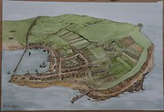
Here is the town of Hartlepool in the year 1485 AD, the first year of the Tudor king Henry V11. The town had prospered since the Norman period some 350 years earlier when the De Brus family had developed Hartlepool as a port for the city of Durham. They laid out the street plan familiar to us today and ordered the building of the first docks and quayside. The town’s status was raised when local merchants bought a Charter from King John in 1201 allowing them to hold a regular market and become wealthy from selling exotic imports like sugar, almonds and spices. Good profits raised demand for retail space close to the docks so much that land was even reclaimed from the sea to form the area of Southgate. The natural shape of the coastline was changed forever.
Religion, too, was important in the lives of medieval people. St Hilda’s church was rebuilt in the early 13th century, as was the smaller St Helen’s chapel just outside the town. The Franciscan order of monks soon followed constructing their Friarage on the eastern side of the town. Visitors to the Friarage would include pilgrims heading for the shrines in Britain and Europe, the sick seeking a cure in the friars’ hospital, or even thieves lucky enough to have found sanctuary within the Friarage and the chance for a new life abroad.
More detail » A.D. 700
 Created by Tees Archaeology/ Hartlepool Council
Donated by Hartlepool Museum Service
Created by Tees Archaeology/ Hartlepool Council
Donated by Hartlepool Museum ServiceIn 2004, Tees Archaeology, Hartlepool Borough Council and The Headland History Group supported by the Heritage Lottery Fund produced a set of four posters which reconstructed the town of Hartlepool over 1300 years.
Graham Hodgson, an archaeological illustrator painted four watercolours of the town for this project. The images are of the original artwork and the notes give the information which was on the posters.
The Anglo Saxon Monastery 700 AD
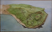
This reconstruction shows the Anglo Saxon monastery in the year 700AD. In common with early Christian sites like Lindisfarne or Tynemouth, it was located on a natural spur of land, surrounded on most sides by the sea. The unfamiliar shape of the coastline is accurate for the time.
A nun named Heiu established the monastery at Hartlepool in the early 640s AD. At this time the area was called Heruteu, which means ‘The Isle of the Hart’. Its most famous resident was St Hild who at one time ruled as Abbess over both Heruteu and the monastery at Whitby. The monks and nuns who lived in the monastery occupied small timber buildings, many of which just had one room. Low fences and ditches kept different living and working areas separate.
The most important area of the monastery would have been the large main church, built of stone near which the monks and nuns were buried. A stone carved with the person’s name marked each of these graves. Important local families who had converted to Christianity were buried in a separate area close to the main entrance.
Heruteu was a place of prayer and learning that attracted pilgrims from all over Britain and Ireland. The inhabitants spent their time in devotion writing religious books and spreading their faith throughout the North. This work went on until the 9th century AD when the monastery was abandoned during the decline of the Kingdom of Northumberland.
More detail » Coronation Year1953
 Created by Tees Archaeology/ Hartlepool Council
Donated by Hartlepool Museum Service
Created by Tees Archaeology/ Hartlepool Council
Donated by Hartlepool Museum ServiceDated 2004
The town in 1953 Coronation Year
In 2004, Tees Archaeology, Hartlepool Borough Council and The Headland History Group supported by the Heritage Lottery Fund produced a set of four posters which reconstructed the town of Hartlepool over 1300 years.
Graham Hodgson, an archaeological illustrator painted four watercolours of the town for this project. The images are of the original artwork and the notes give the information which was on the posters.
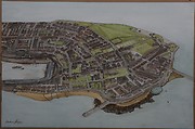
Hartlepool changed greatly in the years between 1900 and 1953 . Many buildings were extensively damaged in WW1 by the German naval bombardment of 16th December 1914. Over 100 people were killed and 500 wounded. Bombing by aircraft in the Second World War also took its toll, both in lives and in further damage to local buildings. The effects of war were still visible in the early 1950s, from the ongoing stationing of troops at the Heugh Gun Battery, to the continuation of rationing in local shops.
The Council also changed the town, demolishing some 1,300 dwellings between 1938 and 1955 in a programme of improvements. While 2500 people were rehoused in the new estates of North Hartlepool, the majority who remained enjoyed new houses with modern facilities and walked in public gardens where the Croft once stood. Luckily, the features of earlier times like the medieval town wall and the Elizabethan manor house survived this upheaval, the latter enclosed within St Hilda’s Hospital run by the new NHS. (NOTE: The hospital is now demolished but the Manor remains currently in a sad state of repair. Sept.2016)
There was much for the town to celebrate in the 1950s. The 850th anniversary of the granting of King John’s Charter was remembered in 1951, while 1953 saw celebrations for the Coronation of Queen Elizabeth the second. Hartlepool also remained a popular destination for both traditional seaside holidays and day trips by the growing number of motorists. However, a new form of entertainment was in the air. Council tenants were first allowed to erect television aerials in 1951.
Other notes on poster:
A sea water bathing pool opened in 1923 and was popular with locals and tourists. It was damaged by a storm in late 1953.
The Borough buildings were built in 1866. They were styled on a Bavarian Town Hall and originally contained public offices, a covered market and a police station.
More detail » Victorian Times
 Created by Tees Archaeology/ Hartlepool Council
Donated by Hartlepool Museum Service
Created by Tees Archaeology/ Hartlepool Council
Donated by Hartlepool Museum ServiceDated 2004
Victorian Times
In 2004, Tees Archaeology, Hartlepool Borough Council and The Headland History Group supported by the Heritage Lottery Fund produced a set of four posters which reconstructed the town of Hartlepool over 1300 years.
Graham Hodgson, an archaeological illustrator painted four watercolours of the town for this project. The images are of the original artwork and the notes give the information which was on the posters.
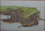
This was how Victorian Hartlepool looked in 1857 after 25 years of industrialisation. The building of the new railway and dock for the export of coal massively expanded the town’s population from about 1300 people in 1831 to just over 9000 in by 1851. Building this new dock and harbour destroyed much of the medieval town wall which was preserved only where it formed a strong sea defence.
While the middle classes bought ‘town hoses’ in streets constructed on what were one open fields, the poor lived in overcrowded slum conditions lacking basic sanitation. The situation was greatly improved in the 1850s due to the efforts of a new Town Corporation concerned to avoid further cholera epidemics like those of 1832 and 1847. The slums of the 1830s were demolished, new water supplies and sewers were constructed and gas lamps introduced to light the streets. The hated workhouse situated in the old Elizabethan manor house built on the site of the Friary, would become te town’s first hospital in 1867.
New places of worship in the 1850s included St Mary’s Catholic Church and several non conformist chapels. There were also 20 schools, most run by private tutors for a handful of pupils from well off families, although the larger like the Prissick charity schools taught 250 children a basic education for no fee. What limited leisure time people had was occupied by the traditional family walk on a Sunday afternoon, the occasional show by a troupe of travelling players, or a visit to one of the numerous public houses.
Notes also on poster:
Elephant Rock: a natural rockformation resembling an elephant carved by the action of the waves. Sadly it collapsed into the sea in May1891.
The original lighthouse: was built in 1846 at a cost of £5750. It was lit by natural coal gas.
More detail »


