Hartlepool Sports & Leisure
Hartlepool Transport
A Potted History Of Hartlepool
Hartlepool Trade & Industry
Hartlepool Health & Education
Hartlepool People
Hartlepool Places
Hartlepool at War
Hartlepool Ships & Shipping

Max Lock Plan 1948
THE 1948 MAX LOCK PLAN AND HOW IT WAS FOLLOWED
In 1948, the joint town planners of Hartlepool and West Hartlepool engaged a well known planning consultant of the time, Max Lock to survey all aspects of the towns and produce a plan from the results. He and his colleagues lived in the town for a year while they prepared this.
Now, well over half a century later, it is easy to see how this plan was used and how much of the town we know now is down to that plan from 1948. His principal findings were that the town had no real centre, needed a clear cut road system, had a deficiency in cultural and recreational facilities and needed new housing free from ‘blight’.
HOUSING
One of Lock’s favourite terms was ‘blight’ as in ‘blighted’ areas, ‘blighted’ housing, areas of ‘blight’ but he conceded that these areas were areas of sociability and warmth. He said 70% of high density houses were blighted. The main areas of ‘blight’ in the plan were:
1.The ‘A’ streets off Stockton Street
2. The area from Brougham Terrace to Belk Street.
3. The area from the North Cemetery to Milton Road.
4. The streets between Elwick Road and Colwyn Road.
5. Caroline Street, Sunderland Street and Charlotte Street (off Elwick Road)
6. The streets between Oxford Road and Cornwall Street.
7. The streets between Stockton Street and Casebourne Road.
In the 1950s and 60s, much of areas 1,5 and 7 were demolished. Parts of areas 2,3 and 7 were demolished a little later and area 4 and 6 still remain.
The small outlying Owton Manor and Rift House estates were planned to be massively extended to accommodate the rehoused families
SHOPPING CENTRE
The plan found that there was an inequality of shop distribution and a very high proportion of corner shops which were not prosperous. In addition there were too many small shopping centres and too many empty shops. Max Lock proposed a new shopping centre between Victory Square and Thornton Street with Binns store and the Central Stores as bulwarks at each end.
It was decided that properties in that whole area between Thornton Street and Victoria Road, although they were not blighted, must be sacrificed for this new shopping centre. In the mid 1960s, this area was demolished and the Shopping Centre was begun.
ROADS
The Max Lock plan also showed a ‘double carriageway’ to be built in Stockton Street which of course happened.
SCHOOLS
It was decided that there was an uneven distribution of facilities at secondary schools. The new Dyke House School and Brinkburn had 9% of West Hartlepool’s children but over 50% of the amenities
Secondary Schools at High Tunstall, Brierton and Owton Manor Lane (Manor) were planned and were built, albeit later than planned.
New Primary Schools were planned at Rift House, Brierton, Rossmere, Owton Manor Lane, Throston, North Lane Elwick and Greatham and the new Golden Flatts School should be a model .
For more detail, comprehensive plans and maps see The Hartlepools A Survey and Plan by Max Lock published by West Hartlepool Corporation
Related items :
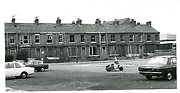
 Demolition of Bell Terrace
 Donated by Robert Wood Collection
Part of the Hartlepool Museum Service collection
Dated 1967
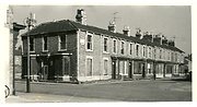
Demolition of Ward Street and Swainson Street
 Created by Robert Wood
Donated by Robert Wood Collection
Created by Robert Wood
Donated by Robert Wood CollectionPart of the Hartlepool Museum Service collection
Dated 1967
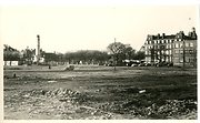
Thornton Street and Peckett Street/Wesley Street
 Created by Elizabeth Law
Donated by Elizabeth Law
Created by Elizabeth Law
Donated by Elizabeth LawPart of the Hartlepool Museum Service collection
Dated 1965
Ward Street demolition
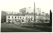 Donated by Robert Wood Collection
Part of the Hartlepool Museum Service collection
Dated 1967